Snow Update
Some flakes are falling over the western Washington lowlands right now--but this is not a serious issue. Roads are still quite warm and there is some minor accumulations on grass for some higher elevation locations (see the picture below at the intersection of I-90 and SR 18 east of Issaquah.
The freezing level (and thus the snow level) has dropped considerably over the past day, with the freezing level (the temperature aloft where the atmosphere cools to 32F) now around 800 ft (see image from Seattle SnowWatch below). A few melting flakes have reached sea level as a weak weather system moves through this morning.
But if you live at a higher elevation, the scene was more winterlike (take a look at the picture at 1170 ft in Bellevue at the home of Dr. Peter Benda).
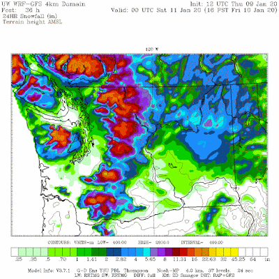
A stronger weather system is approaching the Northwest and will reach us tonight...and we will have some cooler air in place. This is not an ideal situation for lowland snow (temperatures are marginal), but with higher precipitation rates and cooler air holding a bit over northwest WA, there will be light snow, particularly away from the water (see the snowfall total forecast for the 24 h ending 4 PM Friday) north of Everett. Potentially 1-2 inches.
Again, roads are still relatively warm, so I don't expect travel issues in the lowlands. But look at the mountains...they are going to be hit relatively hard, with a foot of snow in places.
Snow will continue in the mountains through Saturday, but no snow over the Puget Sound lowlands on Saturday and early Sunday. Then we get the next snow threat. A low center will move down the coast, while cold air is found over British Columbia (see forecast surface weather map at 10 AM Sunday).
The path of this low is critical. If it were 100 miles south, we could have a snowstorm over much of western Washington, but the current forecast path brings is across northern Washington (see sea level pressure map for 4 PM Sunday below). Cold air will move into Northwest Washington before the low makes landfall (through the Fraser River Valley) and behind that system after it passes, while onshore flow off the relatively warm Pacific will keep things rain from Seattle southwards.
To illustrate this, here is the 24-h snowfall total ending 4 PM Sunday. Bellingham will be whitened as will the folks from Sequim to Port Angeles. Note the STRONG northeasterly winds pushing out of the Fraser Valley gap across the San Juans. Cold air (the "arctic front") will be entering western Washington. Also note the heavy snow in the mountains. Skiers will be all set.
But these snow events are just the preliminaries for what could be a major snow event over western Washington and Oregon on Wednesday and Thursday. Very cold air will be in place and a potent weather system will be approaching our coast (see surface forecast map for 4 PM on Wednesday).
Wow--this has potential. But I have learned from hard experience never to get excited about snowstorms that far out (I have a personal 120hr rule. If the forecast is beyond 120 hours, I try to keep my emotions in check and prevent myself from stocking up on milk and bread).
The amount of snow and where the snow falls will depend critically on the path of the Pacific low and there is considerable uncertainly that far in the future.
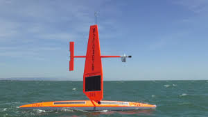
We do have an exciting new tool right now to help with this forecast---a line of unmanned weather observation sailboats a few hundred mile offshore. We will see if they help!
The freezing level (and thus the snow level) has dropped considerably over the past day, with the freezing level (the temperature aloft where the atmosphere cools to 32F) now around 800 ft (see image from Seattle SnowWatch below). A few melting flakes have reached sea level as a weak weather system moves through this morning.
But if you live at a higher elevation, the scene was more winterlike (take a look at the picture at 1170 ft in Bellevue at the home of Dr. Peter Benda).
A stronger weather system is approaching the Northwest and will reach us tonight...and we will have some cooler air in place. This is not an ideal situation for lowland snow (temperatures are marginal), but with higher precipitation rates and cooler air holding a bit over northwest WA, there will be light snow, particularly away from the water (see the snowfall total forecast for the 24 h ending 4 PM Friday) north of Everett. Potentially 1-2 inches.
Again, roads are still relatively warm, so I don't expect travel issues in the lowlands. But look at the mountains...they are going to be hit relatively hard, with a foot of snow in places.
Snow will continue in the mountains through Saturday, but no snow over the Puget Sound lowlands on Saturday and early Sunday. Then we get the next snow threat. A low center will move down the coast, while cold air is found over British Columbia (see forecast surface weather map at 10 AM Sunday).
The path of this low is critical. If it were 100 miles south, we could have a snowstorm over much of western Washington, but the current forecast path brings is across northern Washington (see sea level pressure map for 4 PM Sunday below). Cold air will move into Northwest Washington before the low makes landfall (through the Fraser River Valley) and behind that system after it passes, while onshore flow off the relatively warm Pacific will keep things rain from Seattle southwards.
But these snow events are just the preliminaries for what could be a major snow event over western Washington and Oregon on Wednesday and Thursday. Very cold air will be in place and a potent weather system will be approaching our coast (see surface forecast map for 4 PM on Wednesday).
Wow--this has potential. But I have learned from hard experience never to get excited about snowstorms that far out (I have a personal 120hr rule. If the forecast is beyond 120 hours, I try to keep my emotions in check and prevent myself from stocking up on milk and bread).
The amount of snow and where the snow falls will depend critically on the path of the Pacific low and there is considerable uncertainly that far in the future.
We do have an exciting new tool right now to help with this forecast---a line of unmanned weather observation sailboats a few hundred mile offshore. We will see if they help!


Comments
Post a Comment