Knowing About Rainshadows to Find Sunshine on These Dark Days
The Seattle Times had a front page article today saying half of Seattle's residents are depressed and by a small margin we are the most depressed major city in the U.S.!
Well, there are many reasons suggested for this depression, including the dismal state of our municipal leadership, but the article mentions an old favorite: the lack of sun this time of the year.
Fortunately, this is one problem that meteorological knowledge can help with.
A secret that most meteorologists know: that on most days even in our sodden area, there are regions of sun in the sea of clouds. The areas of rainshadows. And, if you are able to drive a bit, you can often put yourself under the depression-killing rays of the winter sun.
I have talked about rainshadows several times in the blog, but let me provide a brief review. When air approaches a terrain barrier (such as the Olympic Mountains or Cascade range), it is forced to rise on one side (the windward side) and to sink on the downstream (leeward) side. When air rises, it cools and can form clouds, but sinking air on the lee side warms and drys, often providing sunny skies in the rainshadow.
Take today. Where were the sunny spots around noon (in this case, 12:20 PM PST)?
The visible satellite image for that time (see below) tells you exactly where to go: to the southeast of Vancouver island and the Olympic Mountains, as well as downstream of central and southern Cascades. This makes a lot of sense because the general winds were from the northwest today, so those areas are the ones with sinking air. The windward sides of the mountains were in clouds and depressing.
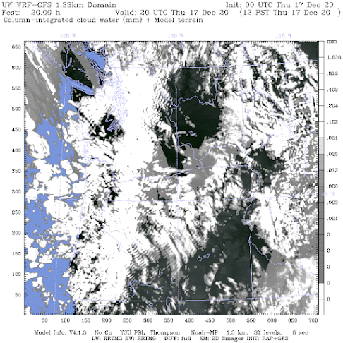
Can we know where the rain shadow will be ahead of time? You bet. Our high resolution forecast models provide cloud forecasts. For example, here is the forecast for noon from a model run that started at 4 PM the previous day (see below). Not perfect, but the rainshadows noted above were relatively well predicted.
To show you that this situation is no fluke, Here is the visible satellite image for Monday afternoon.....some nice rainshadows downstream of terrain. Cloudy over north Seattle (there was a convergence zone going on), but sun to the north and south.
So, if you want to go sun/rainshadow chasing,what do you do?
First, go to my department website and look at the visible satellite animation (click here).
And if you are adventuresome, you can even look at our model forecasts of the clouds (click here).
Perhaps with more local residents using meteorology to find the light, we can give up first place in big-city depression. And replacing several on the Seattle City Council might help as well.
____________________________________________
I will do a podcast tomorrow on the forecast for this weekend and the holiday season. Plus, a special surprise topic for a more in-depth examination. On Saturday at 10 AM, I will be doing a special zoom session with my Patrion supporters. Will talk about the BLOB and the effects on local weather, plus answer questions.


Comments
Post a Comment