Note: I will update Wednesday morning after the new model runs come out.....
The meteorological community is all abuzz about the forecast this weekend: several of the global models are predicting an extraordinarily unusual heatwave this weekend in the Pacific Northwest.
A heatwave so extreme that many locations might experience their warmest temperature on record.
For any day. For any year. And doing so in late June, which is not the usual time for the great temperature records.
Waves are the reason for this heatwave
But there is something else...there is great uncertainty in this forecast and what happens will depend on weather events over the western Pacific during the next few days.
Let me show you... the forecasts are simply insane.
To start, here are the forecast temperatures for 5 PM Sunday based on the excellent European Center model. As high as 121F in the northern Central Valley of California, 113 and 115 in the Columbia Basin, and 104-105 in the Willamette Valley. Only around 90F near Seattle.
Monday afternoon, Portland is predicted to get to 109F, and 121F is forecast near the Oregon/WA border.
The U.S. model the GFS is also going for extraordinary warmth in the region. A "plume" forecast plot for Seattle is shown below with the high-resolution prediction (blue line) and an ensemble of many lower-resolution simulations indicated.
For Monday, the high-resolution run gets to 111F in SEATTLE (the highest on record is 103F); it appears to be an outlier: most of the ensemble forecasts (gray lines) are cooler, with their mean (black line} only reaching 90F.
The UW high-resolution forecast system is going for 110F in Seattle and 120F in Portland (see below). Simply mind-boggling
This is so nuts I can't believe it.
The origin of this potential heatwave is a huge, high amplitude ridge of high pressure aloft (see the forecast for 11 AM Sunday. It would represent the strongest ridge in history for our region.
What is the origin of this ridge? It appears to be forced by a tropical disturbance in the western Pacific that moves northward until it interacts with the jet stream, resulting in a series of downstream waves. Sort of like deflecting a long rope and having all kinds of waves propagating away.
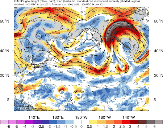
The forecast of upper-level flow (around 30,000 ft) over the Pacific shows the waviness developing (see below). Think of the lines as pressure and the shading telling you how unusual the winds are. Wind barbs are also indicated.
On Tuesday morning, the jet stream is relatively straight over the western Pacific and a weak disturbance is moving northward (indicated by an arrow)
By June 24th, the jet stream has started to buckle, with major waviness over the north Pacific.
And by the 26th, the wave has amplified into a huge ridge over our region
But here is the thing. These kinds of interactions between a tropical disturbance and the jet stream are very finicky. Slight changes in the amplitude of the disturbance and where it hits the jet stream can result in major changes in the creation and motion of the jet stream waves.
This produces a great deal of uncertainty. By Wednesday, it all should settle down and we should have more confidence in the forecast.
My own evaluation from looking at a wide range of forecast guidance is that Seattle northwards will escape the worst of this, with temperatures only rising into the mid-90s, but Portland, the Willamette Valley, and the Columbia Basin will experience historical, extraordinary high temperatures.


Comments
Post a Comment