Heatwave Haze
During the recent heatwave, which peaked in western Washington, western Oregon, and British Columbia on June 28th, many noticed an unusual haze, particularly at lower elevations west of the Cascades.
And this was not wildfire smoke: it was something else.
To illustrate, here is an image from the Space Needle Panocam on June 28th around noon. The image directed towards the Olympics really shows the brownish haze layer.
So what was this hazy miasma over western Washington and British Columbia? It wasn't wildfire smoke, as shown by the NOAA HRRR Smoke analysis at noon Monday, June 28th.
I suspected it was photochemical SMOG and checked with air quality expert Phil Swartzendruber of the Puget Sound Clean Air Agency and he concurred.
What is photochemical smog?
It occurs when sunlight (the ultraviolet component) interacts with human-emitted nitrogen oxides and volatile organic chemicals (emitted by plants or produced by some polluting industries) to produce a witches brew of chemicals including ozone, nitric acid, aldehydes, peroxyacetyl nitrates (PANs), and other secondary pollutants. Some of these chemicals are associated with particles that scatter and absorb sunlight, producing haze.
The production of smog is enhanced by warm temperatures and lots of sunshine and BOTH were optimally available during the heatwave period. Nitrogen oxides can be produced by combustion in fossil-fuel-driven engines.
Ozone in Our Air
Ozone is a wonderful thing to have in the stratosphere, where it helps protect us from ultraviolet radiation. But at the surface it is a bad thing, irritating our lungs and damaging materials such as rubber.
Ozone can be produced by photochemical reactions as noted above, but can also be generated in other ways, such as by wildifres.
Here are ozone values at Seattle and Enumclaw, in the Cascade foothills. You will notice the ozone levels steadily increasing during the heatwave at both locations. There is also a strong diurnal (daily) variation, with sunlight and warm temperatures during the day increasing ozone levels.
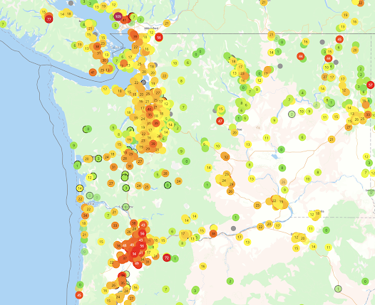
The Environmental Protection Agency's excellent AIRNOW website provided maps of ozone on Monday (see below). I have included both their analysis and observations at individual locations.
Ozone levels were high around Puget Sound and near Vancouver, BC., but generally low in eastern Washington, where there was plenty of sun and warm temperatures. The reason? They lacked the nitrogen oxides and organic chemicals needed for ozone production.
How unusual were the ozone values observed in Seattle?
Below is a plot of daily ozone during the past year at the Seattle Beacon Hill site. June 28th of this year was the highest. Next, highest? During the September 2020 wildfires.
High summer ozone is generally rare in Seattle because of the relatively cool, clean marine air that generally floods into our region on most summer days. Interestingly, the highest summer values are generally observed in the Cascade foothills (e.g., Enumclaw or the nearby Pack Forest), where nitrogen oxides from Seattle and other urban areas combine with organic chemicals emitted by vegetation.


Comments
Post a Comment