Big Winds, Heavy Rain, and Now Thunderstorms
Nearly 100,000 Washington State power customers lost power last night as strong winds first hit Northwest Washington and then spread across the remainder of the western interior as a powerful front crossed the region during the late evening. Trees are very vulnerable to the first windstorm of the season, particularly if they are fully leafed out.

Winds gusted to around 60 mph over Northwest Washington, 40 mph over the lowlands of the South Sound, and reached 103 mph at Camp Muir on Mount Rainier.
The power outage map from Puget Sound Energy last might shows the damage, centered around NW Washington and the south Sound towards the Cascades.

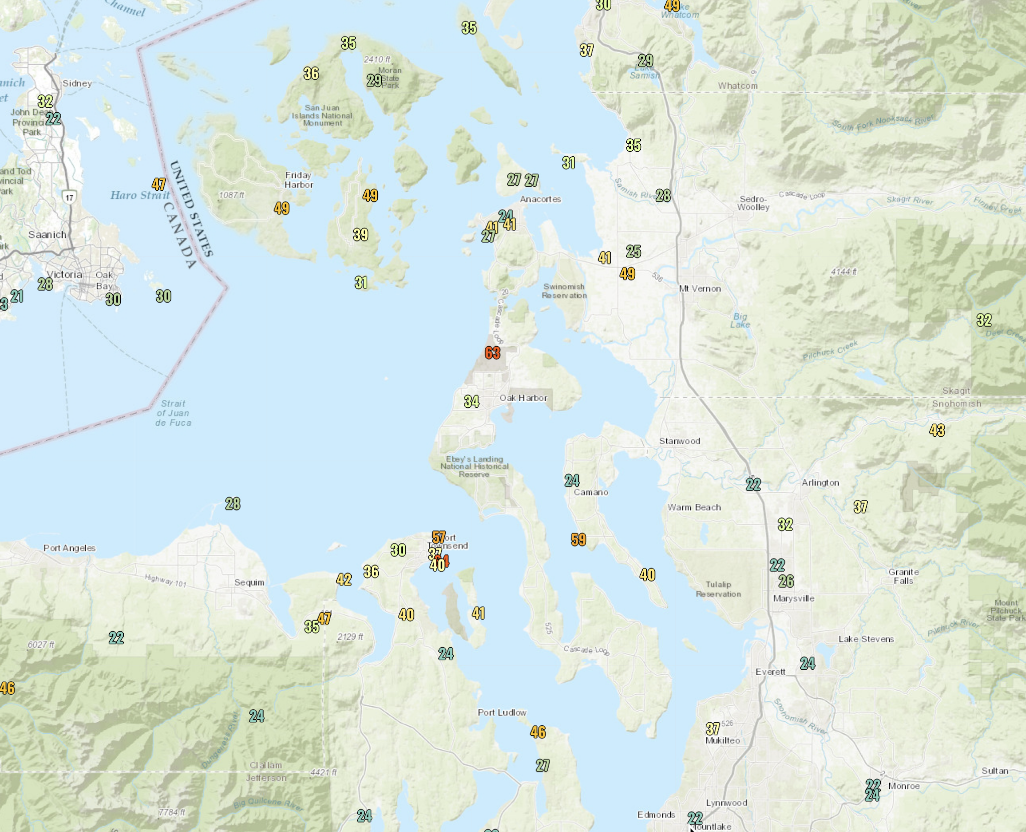
Here are the top wind speeds on Friday (click to expand). A gust to 63 mph a Whidbey Island Naval Air station, nearly the same at Port Townsend, and nearly 50 mph on the San Juans. These winds occurred during the afternoon before the front made landfall.

Over the south Sound, the winds gusted to 40-50 mph last night over the lower elevations, 70-80 mph on lower peaks, and over 100 mph on Rainier.

These winds occurred during the later evening as the strong front went through....the feature I warned about in my last blog. The radar image at 11:11 PM last night showed a line of strong radar return with the front (the arrow shows you the feature).

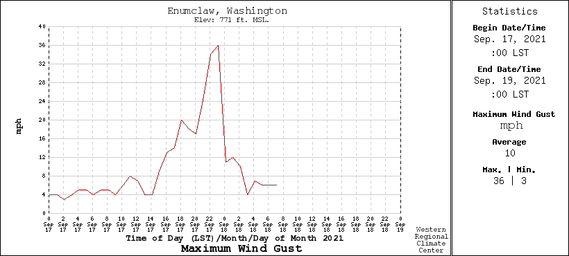
The frontal winds came up very quickly and dropped very quickly, as illustrated by the winds at the USDA RAWS site in Enumclaw, southwest of Seattle. A gust to 36 mph with the front.
And this was a particularly strong front with a VERY large temperature change associated with it. To prove this, here are the temperatures at Enumclaw. Temperatures rose before the front to 72F and then crashed to the lower 50s within a few hours. Don't see that kind of large temperature changes with fronts very often around here!

Precipitation? This system brought plenty, ranging from 4-6 inches in the mountains to around a half-inch in the rain shadowed areas.

Rivers are way up right now, with many Washington rivers above normal levels. But no flooding because they started at below-normal to normal levels.
Part II. Thunderstorms and showers
The excitement is not over yet! With an upper-level trough/low approaching and cooler air moving in aloft, the atmosphere will be primed for convection and thunderstorms. So get your lightning rods ready.
The latest visible satellite image shows the front moving through right now (the solid band of clouds) but also displays lots of convection (instability showers of cumulonimbus) offshore (these are the popcorn-appearing features). Those showers are strong and have our names on them. But most of you will have a break this morning and early afternoon--so have fun outside this morning if you can.

A particularly potent band will come through this afternoon and evening (see the simulated radar image at midnight tonight below). Many of you will hear the rumblings of thunder. And more shower action on Sunday.
It is good to have active weather back...and I note that it is quite typical for this time of the year.

Forecast radar reflectivity at midnight tonight.


Comments
Post a Comment