Heavy Rain and Rapidly Rising Rivers: The Details on the Friday/Saturday Inundation
If you were planning to take a hike on Friday, forget it. Thinking about painting your house? No way.
It is going to be very, very wet on Friday and early Saturday, and I suspect some daily precipitation records will be broken.
But let me give you the details.
Let's start by showing you the latest accumulated precipitation totals forecast by the European Center model for the period ending 5 PM Sunday. Virtually all of the mountainous areas of the region will get more than 2 inches, with some being hit by 5 or more (particularly the Olympics and North Cascades).
How much confidence should you have in this forecast? An important question.
We are close enough in time, that the models should be relatively locked on to the correct solution, but as I have discussed many times, the best way to get at uncertainty is to look at ensembles of many forecasts, each slightly different.
So take a look at the fancy presentation of the ensemble precipitation forecast from the top-of-the-line European Center ensemble system (below). You are looking at accumulated precipitation at SeaTac Airport over time (time increasing to the right).
The average of all the ensemble members is shown by the green line and the extreme range of the forecasts (the highest and lowest forecasts) is shown by the brackets. The blue boxes show you the forecasts that encompass the forecasts relatively close to the median (the median is the value in which half the forecasts are greater, half are less).
Wow... an amazing forecast, with the ensemble going for around three inches over the entire period.
Considering that the average MONTHLY rainfall at Seattle is about 1.6 inches, that is a lot. The spread of the forecasts is relatively small for the big wet day (Friday)...so there is great confidence that Seattle is going to be very, very moist.
The rain shield will arrive in the western interior around sunrise Friday and the heavy rain will extend into Saturday morning. Cool and showery over the weekend.
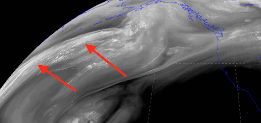
The moisture that will hit on Friday is already streaming towards us from the western Pacific (see arrows in the latest water vapor satellite imagery below).
Now let me emphasize that there will be considerable horizontal variation in the rainfall. To show you this better, here are the high-resolution forecasts by the UW model of total precipitation for the 48-h ending at 5 AM Saturday.
Lighter amounts (less than an inch) to the northeast of the Olympics..that is the rainshadow effect to the lee (downstream) of the high terrain of that barrier. More rain south of Seattle than north of the city. Big increases on the windward side of the Cascades...and, of course, less rain to the east of the Cascade crest.
So head to Port Townsend or southern Whidbey Island if you want to escape the worst of it.
Two more days, it will be here.
The impacts of the precipitation on our rivers will be profound.
Right now most of the west-side rivers are below normal to normal. But they all will be above normal by Sunday.
To illustrate, here are the current and predicted flows from the NOAA/NWS River Forecast Center for the Snoqualmie River at Snoqualmie Falls. HUGE, rapid rise to near-record levels. The falls will be quite a sight on Sunday. And you can get a nice breakfast there as well.
Finally, some historic context. Below is a plot of the record daily precipitation amounts for SeaTac Airport. Middle to late September has had some big events, reaching about 1.5 inches. And I suspect most are like this one.....tapping significant moisture from the western Pacific.
Enjoy the change....and make sure your umbrellas are handy. And I didn't even get to the issue of strong winds. Next blog.


Comments
Post a Comment