The Bomb Cyclone Offshore
The next 24 hours are going to be meteorologically exciting as a powerful storm grows rapidly offshore.
And before I say more, let me make clear that the inland areas of the Northwest will NOT get a major blow from this. Along the coast and particularly along the coast of Vancouver Island, this will be a significant event.
But this storm is remarkable for several reasons and thus is worthy of description. And is predicted to be a bomb cyclone, in which the central pressure lowers by more than 24 hPa in 24 h.
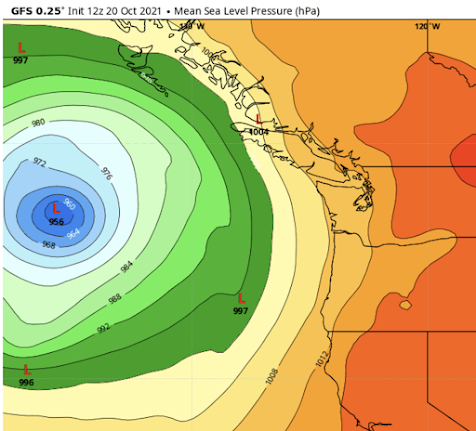
The latest NOAA/GFS forecast for sea level pressure at 5 AM tomorrow morning, shows a deep low off our coast, with a central pressure of 956 hPa. A very, very deep storm for our latitudes, and lower than some category 1 and 2 hurricanes. If this storm had been shifted a few hundred miles eastward, the damage would have been terrible. But it will not do this: model solutions have converged, with little chance of an inland path.
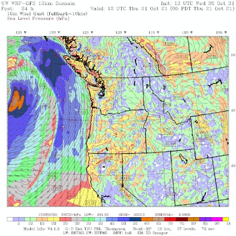
The wind forecast for 5 PM tomorrow shows gusts reaching 50-60 knots off our coast, and even stronger near the low center.
And the Seattle Windwatch wind gust forecast for 11 AM tomorrow predicts 60-80 mph just off the coast, and 30-50 mph gusts along the Washington coast and over the western Strait of Juan de Fuca. Not a good day to head out to sea.
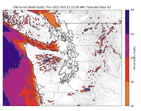
The most extreme coastal winds will be along the northern coast of Vancouver Island, where 60-70 mph gusts (orange colors) are predicted around 11 AM. This is the result of a strong pressure difference coupled with the high terrain near the coast.

If this storm pans out, it will be a remarkable success for numerical weather prediction, considering the difficulty of predicting the rapid intensification of a tropical system moving northward into the midlatitudes.
Imagine.
Predicting the path of a storm over thousands of miles, as it switches its energy sources (from warm water and tropical moisture to horizontal temperature differences) and structure (symmetric tropic storm with fronts to a highly asymmetric storm with fronts), while predicting radical changes it is strength....and doing it all correctly.... is an extraordinary feat.
A feat of prediction we could not have done two decades ago.
And to be a little controversial for a second, some of this extraordinary technology might be of value to other communities, such as those that do epidemiological prediction.
_____________________________________________


Comments
Post a Comment