A Difficult Snow Forecast--As True of Most Western Washington Snow Events
Forecasting snow in western Washington is very difficult, even with modern prediction tools.
Before high-resolution models and satellite observations over the Pacific, it was nearly impossible to accurately predict local snow events and major local snowstorms occurred with little warning (for example, December 18, 1990).
Consider:
1. There is roughly a one to ten ratio between precipitation totals (amount of water falling from the sky) and snow totals, so a small error in precipitation amounts results in huge snowfall errors. Making a 0.10 error in precipitation provides a 1-inch error in snowfall.
2. Temperatures over the western lowlands are often marginal for snow. Right on the edge. So small temperature errors can produce huge changes in snowfall. Same with small changes in elevation or distance from the warm water.
3. There are huge local differences in precipitation because of our local terrain, such as rainshadows, convergence zones, gaps winds, and more. Plus, our complex land-water contrasts.
It ain't Kansas around here. And forecasting snow in Kansas is a piece of cake compared to our challenges.
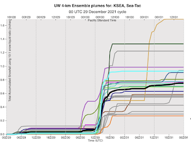
The snow forecast tomorrow has all of these elements, with the snow mainly between midnight and 10 AM,
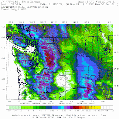
Here is the snowfall total for the period through 2PM Thursday. Healthy totals in the mountains. Little on the coast and the Strait where temperatures will be too warm. Less in the lee of the Olympics mainly because of snow shadowing in the lee of the Olympics. And temperatures will be on the edge for the southern Sound (yes--Puget Sound will see temperatures rise above freezing tomorrow late morning and afternoon)


Comments
Post a Comment