Why Does Western Washington Have Some of the Worst Roadway Icing in the Country? And the Next Snowstorm in Sight
Western Washington can brag about world-class coffee and leading corporations, but did you know we also have some of the worst road icing conditions in the nation when we get some snow?
Icing so bad that mayors can lose their jobs when they forget this meteorological fact?
Icing that can cripple parts of Seattle, killing and injuring both drivers and pedestrians?
It happened again last night and today. Let me tell you why.
Western Washington has a mild winter climate and our soils and roads cool down in autumn, of course, but remain well above freezing during the winter.
Then we get a snow event, with several inches falling on the roadways. This snow starts to melt into a slush layer.
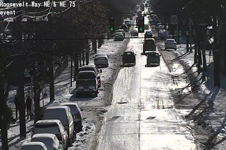
Next, much colder air comes in, as the low center and upper trough that produced the snow moves out. The air temperatures become cold enough that the slush layer begins to freeze...and if cold enough (like yesterday today), it freezes solid to the roadway surface (and almost impossible to remove at this point).
The only way to stop this is to pretreat all roadways with a deicer (such as salt or potassium chloride) BEFORE the show falls and to remove snow after it falls, but before it freezes. Judging from driving around Seattle today, not enough of both were done. Many of the city's major roadways are not in good shape.
Another interesting aspect of this event has been the terrific steam fog produced over the Sound and other local water bodies. When very cold air passes over relatively warm water, you can get tendrils of steam fog.
To illustrate, take a look at a video shot from the north side of the Kitsap Peninsula by Greg Johnson of Skunk Bay Weather.

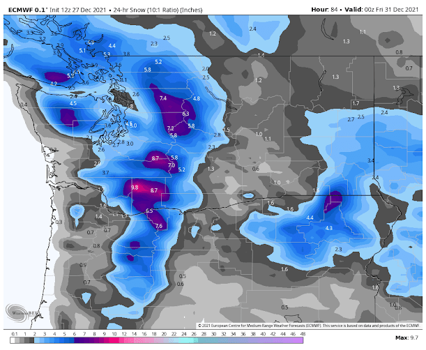
Thursday Snow?
Here is the European Center 24-h snowfall ending 4 PM Thursday. 4-5 inches over Seattle.


Comments
Post a Comment