The Mid-March Precipitation Transition over the Northwest
Residents of the Northwest are a savvy group regarding precipitation, considering their considerable experience with the wet stuff.
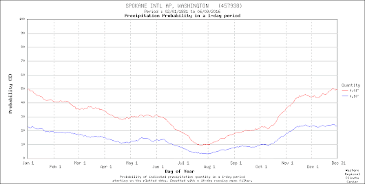
And the really precipitation-aware know about an interesting subtlety: the late-winter precipitation plateau and the mid to late March transition over western Washington. And the eastern Washington precipitation leveling during spring. And more.
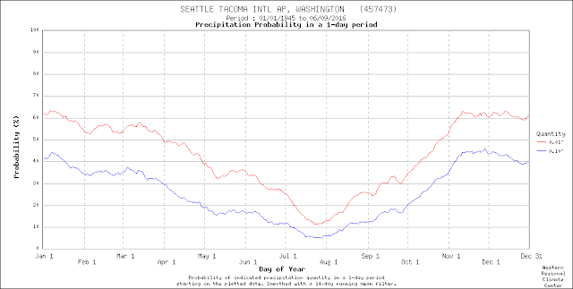
The wettest period at SeaTac is from mid-November through early January, when the incoming storms off the Pacific are strongest and more frequent. Then the probability of precipitation declines a bit in January, followed by little change through mid-March. Subsequently, from the last few weeks of March through early May, precipitation significantly declines. I call this the "spring drying."
Interestingly, there is a bit of an uptick in Seattle's precipitation frequency in late May--at the beginning of the June Gloom period. There are two reasons for this. First, high pressure building over the eastern Pacific starts pushing more moisture into the region during that period, resulting in light rain. Also, we can get some convection and thunderstorms during that period, as the stronger sun drives convective showers.

The subtleties of Northwest weather are always fascinating. You start with variations in the storms and moisture coming off the Pacific. Add to that changes in vertical stability and thunderstorms/convection as the temperature change with height changes by season. Varying winds during the year alter the effects of terrain (windward enhancement/lee rain shadowing). The precipitation story is complex and nuanced.


Comments
Post a Comment