The Tactical and Strategic Implications of the Weather Situation in the Ukraine
Throughout history, weather has played a critical role in war, and thus it may be of value to review the past, present, and future weather situation in Ukraine to garner insights into the future of this terrible conflict.
Weather Conditions for Offensive and Defensive Operations
Cloudy, rainy, and low-visibility conditions generally favor defense, since offensive operations--from aircraft-based attacks, intelligence collection from aircraft or satellites, and artillery targeting--are undermined by stormy, rainy, or cloud-enshrouded situations.
February was drier and sunnier than normal over Ukraine, and was followed by a cool/cloudier period in early March. During the last week anomalous high pressure has existed to the north of Ukraine (see upper-level map yesterday, below), producing warmer and drier conditions over the country. This has been beneficial to Russia's offensive operations.

This situation--favorable for the Russians--will continue for another 3-5 days, but then there will be a major shift in the atmospheric structure with a deep trough of low pressure developing to the north (see forecast map for March 27). Weather conditions will deteriorate over Ukraine, aiding the Ukrainians.
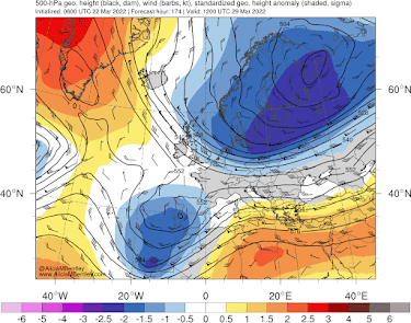
The European Center forecast of the simulated cloud image for Monday (March 28th) shows extensive deep clouds over Ukraine.


"General Mud"
What about the situation on the ground? As noted in a previous blog, and numerous accounts in the media, Ukraine, eastern Russia, and the adjoining areas are well known for very muddy conditions during the spring (as snow melts into poorly drained soils) and autumn (with the return of fall rain), while the hard-frozen soils of mid-winter and dried soils of summer (with dust) are favorable for military operations.
Currently, snow has melted over most of Ukraine, except for the far eastern regions, as apparent in a visible satellite image yesterday and the European Center snow analysis (both below).
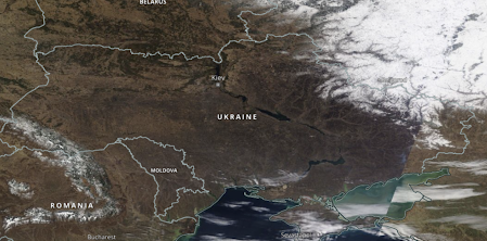
MODIS visible satellite image on Monday, March 21. Snow is evident over the far northeast side of Ukraine.

To gain some perspective on the situation, the precipitation situation in Kyiv is shown below. There was no snow at the end of February (no data in March on this figure.).


Compare this against a more typical year (2018), where the snow extended into March.

Snowmelt is ahead of schedule because of a warm, dry February and the warm/dry conditions of the past week.
You can get an idea of where the snow has melted this year by looking at the visible satellite image on Feb. 13th (below). Lots of snowmelt then over the northern part of the country compared to the image shown earlier.


Comments
Post a Comment