The Last Chance for Lowland Snow
If you are living in western Washington, the next 48-h will afford your last chance to see some falling snowflakes.
But don't start thinking about sledding and snowballs--there will be no lowland accumulation.
Although it is unusual, snow has fallen and accumulated over the Washington lowlands in April, something shown by plots of extreme snowfall amounts in Seattle and Bellingham below.

.gif)
The freezing level over us right now over Puget Sound is now around 1700 ft. Colder than freezing above and warmer than freezing below. Most precipitation starts as snow high up and takes about 1000 ft to melt when it falls into above-freezing temperatures.
Thus, right now, wet snow could fall to around 700 ft.

As shown by the forecast surface weather map below for 5 AM Sunday morning, cool air (blue colors) will be over the region. And if you look closely, you can see a low-pressure center over the southern tip of Vancouver Island. That weak disturbance will result in light rain...with a few embedded snowflakes.


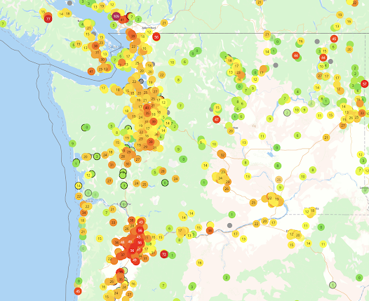
But look at the predicted snowdepth at the same time (below). The lowlands are bare--but lots in the mountains.


This system will bring another chance of snow, even with temperatures being marginal. Take a look at the 24h snowfall total ending 5 PM Monday. Some locations in SW Washington might see some flakes.

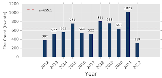
Anyway, no one is going to call this the great April snowstorm....but it will serve to remind us that the atmosphere can be quite cool in April. And this snow event will freshen the Cascades snowpack, which is good for many reasons. No early wildfires this year.

Comments
Post a Comment