La Nina is Not Going Away. What does the mean for this summer's weather?
It is now clear that La Nina is not going away, and may hang around into next winter.
Cold water is entrenched over the central and eastern tropical Pacific (the definition of La Nina) and the latest forecast model runs suggest a continuation into fall.
Several of you have asked: what does this imply for our summer weather?
Let me tell you.
But first, the bottom line: the summer effects of La Nina are modest, but will push the western side of our region towards cooler than normal conditions.
The Impacts
During La Nina years, sea surface temperatures off the West coast are usually cooler than normal, and those cooling effects spread inland.
To illustrate, here is the sea surface temperate difference from normal for the summer months (May through September) for La Nina years. Blue colors are cooler than normal.
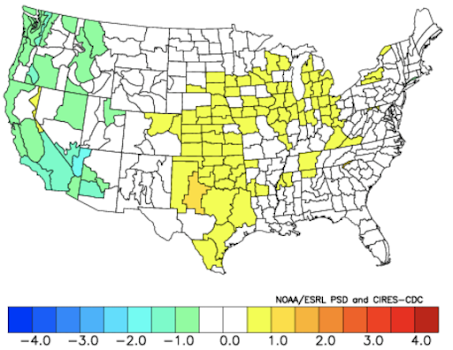
And if we average surface air temperatures for La Nina summers and subtract those temperatures from normal, we find that cooler than normal summer temperatures (e.g., green colors in the figure below) occur from California to Washington during La Nina summers (temperatures anomalies in degree C are shown below).In contrast, West Coast precipitation is hardly changed...perhaps slightly drier on the western sides of the Cascades. I suspect this is because the colder water works against thunderstorms. Interestingly, La Nina seems to have more summer impact over the Midwest U.S.


.png)
.png)


Comments
Post a Comment