Winter Rainfall in Spring
One of the problems in being a meteorologist is that you suffer twice with bad weather: once with the forecast and then again when you experience the ill weather.
And the suffering is getting worse.
Tomorrow will be the last dry day for a long time, and this May will end up with rainfall more appropriate for February.
Let me show you the dismal story in 48-h chunks.
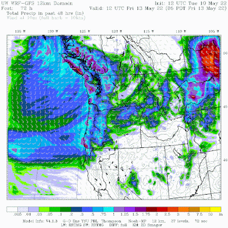
Wednesday will be mainly dry, but Thursday will be wet, with the 48-h precipitation total ending 5 AM Friday (below) showing a moderate atmospheric river coming in off the Pacific, with rain enhanced over the mountains.
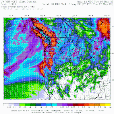
Over the next 7 days, the totals are...well..scary, with a number of mountain areas getting three to five inches. A lot any time of the year, but unusual for May.
Eastern Washington gets substantial rain, particularly in the "extreme drought" area from Yakima to Moses Lake. Rivers are also above normal within the drought warning area.
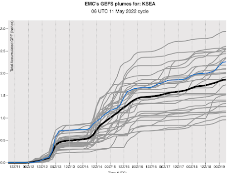
If you want to view the relentless nature of the upcoming precipitation, check out the prediction of rainfall at Seattle from the NOAA/National Weather Service GEFS ensemble system (see below). Each gray line is the cumulative rainfall at SeaTac for a different forecast and time increases to the right. The black line is the average of all the forecasts. Starting tomorrow, there will be nearly continuous rain, with SeaTac ending up with 2 additional inches.
Keep in mind that the normal TOTAL for the month is 2 inches and we already have two inches in the rain gauge. So we will have TWICE the normal rainfall by May 19th....and the month will not be over.
Now the really depressing thing is that normally there is a major warm spell in mid-May, one that always came like clockwork. But not this year.
Do you want to experience 70F or more during the next few weeks? Go to Hawaii.
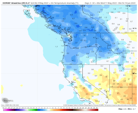
The latest extended European Center temperature forecast is predicting much colder than normal conditions into the end of June (see below, blue colors are below normal). Unbelievable.
Thursday will probably break the record for having the record low high temperature at many western WA locations.
Being cold and wet through May, with a bountiful snowpack, has major positive implications for the wildfire season, something I will discuss in a future blog.


Comments
Post a Comment