It's Back!! The Pesky Upper-Level Trough Will Bring Cool Temperatures and Some Rain This Weekend
Some things in life are not fair. We suffered from a cool/wet spring due to a persistent area of low pressure just offshore.
Yes, it had its good points: eliminating drought, providing a bountiful snowpack, and suppressing wildfires. But mildewed Northwest folks need a break with sun and warmth.
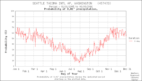
And if we are ever going to get dry weather it should be now, since the second half of July is climatologically the driest period in the year, as shown below.
A threatening low-pressure area has been hovering offshore, and one of its evil progeny will push into our region on Saturday and Sunday.
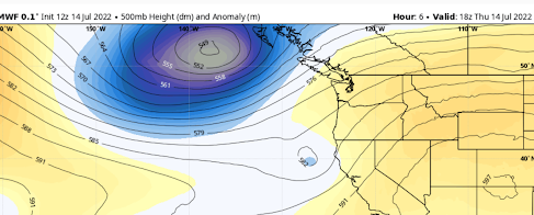
To see this, here is an upper-level map (500 hPa pressure level, about 18000 ft) for today at 11 AM. You can think of the lines as pressure and blue/gray colors indicate pressures that are much below normal. This is also known as a trough.
A ridge of high pressure is inland, keeping us near normal in temperature and relatively dry.
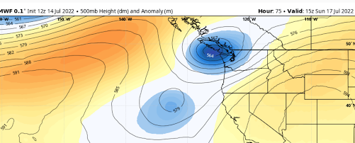
But look at the forecast for Sunday at 8AM (below), the low pressure heads towards the coast, with a potent mini-low right off Vancouver Island.
Not good for sun lovers. This will bring clouds into the region, particularly on Saturday and Sunday.
Serious rain will move into southern BC and western WA and northwest Washington will get a significant taste of it (see the totals through 5 AM Monday below). Showers will move to the coast late Fridays, with light rain reaching the Cascades on Sunday. Some sprinkles continuing on Sunday.
Temperatures will be much cooler than normal on Sunday, with the European Center model only going for 67F that day. You want sun on Sunday? Head to eastern WA.
But there is good news...the trough will move through quickly, with temperatures rebounding next week.
Announcement
I will be doing a special online zoom session for Patreon supporters on Saturday at 10 AM. Come with your questions....and I will talk about the summer outlook as well.


Comments
Post a Comment