All heat waves are not alike.
Some are warmer than others, some are short (one day), others last as long as 5-days, some have temperatures rise and fall quickly, while others have a slow rise and rapid fall--or vice versa. This one won't be a record-breaker, but will extend over 4 days.
We are now in the warmest time of the year (see below), so a visitation from a heat wave is not unexpected (see SeaTac temps below, the arrow is today, average max is red, record highs are yellow).
The upcoming warm period will be pretty run-of-the-mill on the west side of the Cascades, but more notable east of the Cascade crest.
Here is the latest predictions from the NOAA/NWS National Blend of Models (NBM), which combines models, observations and statistics. NBM has done well with past heat waves!
In Seattle (below), high temperatures will rise into the upper 80s on Monday and the low 90s on Tuesday and Wednesday, slowly falling into the upper 80s on Thursday and Friday. And 80+ temperatures continue for another several days.
A long warm period, so make a lot ice cubes and clean the blades of your window fans.
But the lows will drop into low to mid-60s each night, so cooling will be possible.
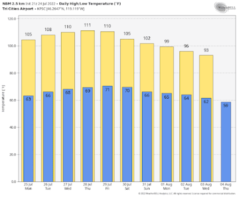
But eastern Washington will be a different story....and a hot one. Highs will climb to 110 or 111F on Wednesday through Friday, with lows dropping only to around 70F.
That will be unpleasant.
The warm weather will be associated with the building of a ridge of high pressure aloft over the eastern Pacific. The amplitude of this high pressure (or ridge) will be a maximum on Monday evening
500 hPa heights on Monday evening. Red is much above normal
The ridge weakens a bit and moves eastward on Thursday. This slowly changing ridge is why the heat continues so long.
Thursday afternoon
The colors are anomalies for normal in standard deviations.
There are some folks that are concerned about wildfires. The heat in itself will not start fires, although it will contribute to drying of surface fuels. But eastern Washington grasses are already dry enough to burn.
What is needed is ignition and wind. Ignitions we can control (except for lightning). But what about wind?
The big threat is at the end of the heat wave late in the week, as cooler air moves into western Washington resulting in higher pressure there and a greater pressure difference across the Cascades.
The hot-dry-windy index that combines a measure of drying conditions and winds shows high values (yellow and red colors) east of the Cascade crest on Friday afternoon (see below).
We better be careful!

.png)


Comments
Post a Comment