SuperMonsoon Hits the Southwest U.S. and the Northwest Gets a Piece of It.
There is a good name for it: a SuperMonsoon.

In my previous blogs, I talked about the nature of the Southwest (or North American) Monsoon, and how water vapor from the Gulf of Mexico swings around a high-pressure area into the Desert Southwest from June to August.
As a result, the southwest U.S. is usually MUCH wetter than the Pacific Northwest during mid-summer.
The Southwest Monsoon has been particularly active this summer with lots of thunderstorms and an unusual westward and northward penetration of moisture.
Take a look at the percent of normal rainfall during the past month.
Wow. Some areas (Nevada and southwest California) have been hit by over 800% of normal rainfall. Folks needed an umbrella in Las Vegas!
.png)
.png)
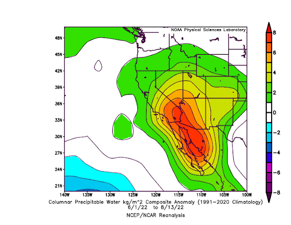
This summer's monsoon has been associated with unusual amounts of water vapor moving northward out of the tropics.
To demonstrate this to you, below is a plot of water vapor anomaly (difference from normal) for June 1 to August 13th. Greens to red are above normal. Wow...lots of oranges and reds....well above normal water vapor amounts heading northwestward out of Mexico into the Desert Southwest! Some of it even reaches the Pacific Northwest.
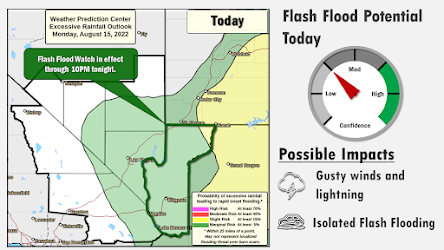
With all the moisture, bringing precipitation and thunderstorms, the Las Vegas National Weather Service have been busy putting out flash flood warnings (see one from yesterday below)
Looking at the total rainfall map since June 1, only showing values above 1.5 inches, lots of areas in the southwest have gotten over 4 inches, with a few locations getting 5-17 inches.

Interesting, last year was also a big Southwest Monsoon year...in fact, even more impressive than this year.
Is there a trend in Southwest Monsoon rainfall? To gain some insight into this question, below is a plot of July Arizona rainfall for over a century.
This year the July rainfall across Arizona is clearly above normal (and the heaviest precipitation was during August), but last year had exceptional July rain. Some really heavy rain about 100 years ago, and July 2020 was very dry. But all and all, a lot of precipitation variability but with little trend.
 Some climate model studies suggest that the Southwest Monsoon will get drier and others project little overall change (drier first half, wetter second half of the summer). But considerating that thunderstorms/convection produces most monsoon rainfall and that climate models don't handle them well, I suspect the jury is still out on the topic.

One final thing. Last year's bountiful Southwest Monsoon resulted in heavy grass growth that contributed to the terrible New Mexico fires earlier this year. The Forest Service, BLM, and other wildfire agencies will need to be prepared for an active wildfire season next year.


Comments
Post a Comment