The Final Heatwave of the Summer? When does the threat disappear?
Even with cool temperatures this weekend, the specter of more warmth is on the horizon.
But is this the end of the threat of real warmth in our region?
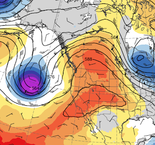
Let's start with the forecast. Another ridge of high pressure will build over the West Coast on Monday and Tuesday, as illustrated by the upper level (500 hPa pressure, about 18,000 ft) map for Tuesday at 5 PM. The red indicates higher than normal pressure, the blues and purples below normal (troughing.
The latest National Weather Service National Blend of Models temperature forecast for Seattle indicated highs in the upper 80s on Tuesday and Wednesday before an extended cool-off to more seasonal temperatures around 80F. Importantly, lows will reliably decline into the 50s, ensuring a good night's sleep.
As apparent to all of you, the nights are getting longer, the days shorter, and the strength of the sun's rays is ebbing. Eventually, we simply won't be able to get into the 80s and 90s anymore.
The bottom line: Based on the current forecasts, it appears that after mid-week, there is probably little chance of Seattle exceeding 90F for the rest of the year. And after Friday, little chance that Richland will exceed 100F for the remainder of 2022.
Reminder: I will be teaching ATMS Atmospheric Sciences 101 this fall.
Like last year, I am teaching atmospheric sciences 101: a general introduction to weather and climate, this fall. You can learn more about the class on the class website. I talk about everything from the basics of the atmosphere to weather prediction, thunderstorms, hurricanes, and local weather to global warming and climate.
I will be teaching the class in person at the UW, but will also make it available over zoom. Thus, folks can take it remotely.
If you are a UW student looking to learn about weather or a non-student interested in the topic, I welcome you to join me this fall. My first class is on September 28th.


.png)
.png)


Comments
Post a Comment