Air quality is rapidly improving west of the Cascade crest as the easterly (from the east) airflow has been replaced with southerly (from the south) winds aloft. And the change of wind direction and increased humidity should allow rapid control of the Bolt Creek fire near Route 2.
This morning clouds and wildfire smoke is found aloft over our region...and you can thank California for much of that!
First, the air quality situation.
The latest AIRNOW map shows good air quality on the southwest Washington coast (green) and moderate levels (yellow and orange) around Puget Sound. Poor air quality is found near the Canadian border, but that should blow north during the next few hours. Air quality is only slightly high over the eastern slopes of the Washington Cascades....unfortunately, that may worse during the next day.
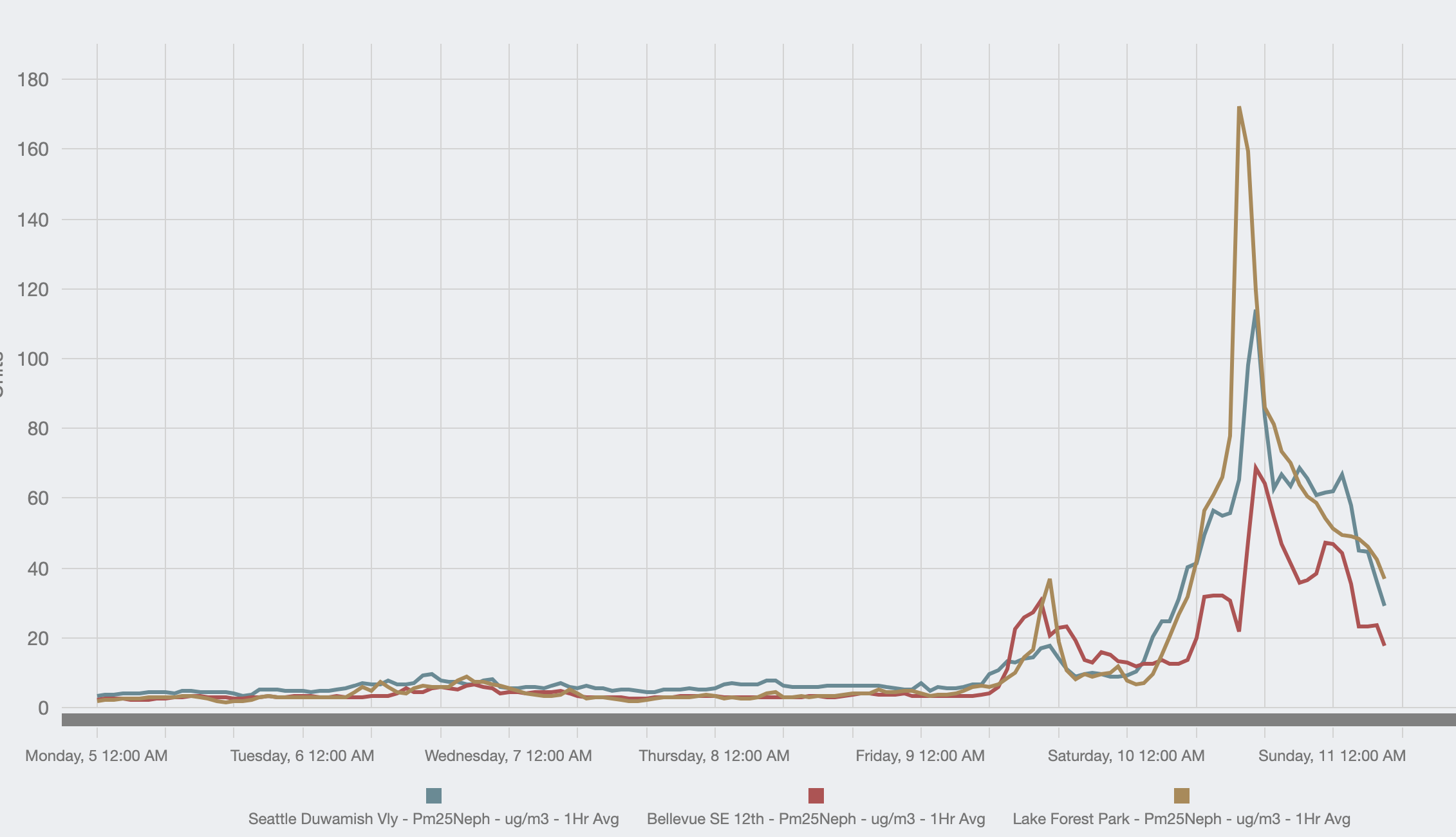
You can get a better idea of the trends of air quality (actually concentration of small particles--PM2.5) from a plot courtesy of the Puget Sound Clean Air Agency. This shows particle concentrations at Seattle, Lake Forest Park (north of Seattle) and Bellevue. A peak yesterday (particularly at Lake Forest Park downwind of the Bolt Creek fire), but a major decline this morning by roughly 75%.
And there are some clouds aloft and even a few sprinkles this morning. To appreciate that, take a look at the latest regional visible satellite image. You can see the middle-level clouds (really white objects with shadows) and lots of low clouds over the Pacific. Smoke (middle grays) is really obvious over eastern WA and OR, as well as the central Oregon Cascades.
The clouds, embedded in southerly flow, can be traced all the way back to Hurricane Kay off of southern California. An infrared satellite image (below) shows this. No need for a tropical vacation...the tropics are coming to you!
And a lot of the smoke over our region (mainly aloft) is also from California (see NOAA HRRR Smoke forecast for this morning), with a boost from the Cedar Creek fire in Oregon.
Meteorologically, the key factors controlling our improving situation are the inland movement of the region of high pressure (the ridge) inland and the approach of low pressure offshore. The weather map for roughly 5000 ft (850 hPa pressure) at 11 AM today (Sunday) shows the situation. The result is increased airflow in the lower atmosphere from the south and southwest.
As a result, the latest HRRR smoke forecast is for the smoke to move out of western Oregon and Washington at low levels (8 PM tonight shown). If your live in Puget Sound country or Portland you will breathe well tonight. But our boon will bring declining air quality east of the Cascades. Sorry.
There are a lot of lessons from this event. We were able to forecast the potential danger (strong, dry easterly winds) with great skill. Portland Gas and Electric strategically de-energized power lines, and at this point I have heard of no new fires down there.
The west-side fires occurred in exactly the period they have always done (late summer) and under exactly the situation that is typical...strong easterly flow. Clearly, the Bolt Creek fire was human-caused, which implies we need to get the message out more clearly about taking great care during such (short) threatening periods. Certain media have been pushing a global warming connection, but I should note that this is not clear: the latest regional climate simulations suggest that strong easterly flow during this time of the year will weaken under global warming. Another important issue is the condition of the forests that burned....but that analysis will wait for another blog.


Comments
Post a Comment