This fall has been wonderfully warm and dry in the Northwest.
Plenty of sun and perfect temperatures. My tomatoes have been glorious. And the warmth has reduced the need for heating, which helps reduce global warming.
But all good things must end and major forecat systems predict the transition to more typical cool/wet weather next Friday.
It is quite typical for the first half of October to be sunny and warm in our region, but on most years there is a transition to cool/cloudy/wet weather during the third week of the month. And this year is no exception.
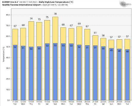
Below is the latest temperature prediction from the European Center's ensemble of many forecasts. One last warming period this week with a steady rise into the upper 70s by Sunday. Perfect weather for any outdoor activity. Then a minor trough of low pressure moves south of us early next week, dropping temperatures into the upper 60s. Still nice.
But the bottom drops out on Friday and Saturday, with highs only rising to the upper 50s.
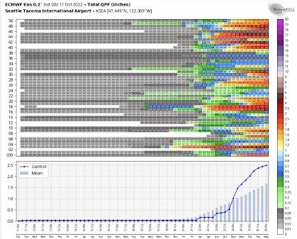
And they are going for rain.
Below is the cumulative precipitation from each forecast in the European Center ensemble (top panel), the forecast of the high-resolution ensemble member (blue line) and the average of all the ensemble members (light blue bars). This is serious rain folks (1-2.5 inches).
The key element of the transition is a major reorganization of atmospheric structure over the Pacific.
Let me show you.
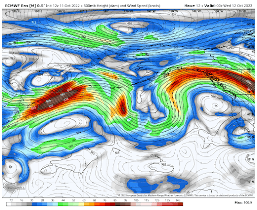
Below is the upper-level pattern (500 hPa, about 18,000 ft) for today at 5 PM (the average of the very skillful European Center ensemble of many forecasts). The shading shows the wind speeds.
Today, there are strong undulations in the height/pressures, with a big ridge of high pressure off our coast. The strong winds (the jet stream) go far north of us. A dry/warm pattern for the Northwest.
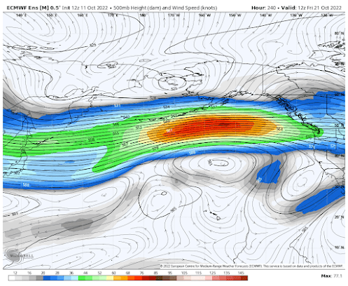
But now look at the forecast for 5 AM next Friday. Wow ...a big change. The wavy nature of the flow aloft is gone, replaced by a strong jet stream heading right toward our region.
The atmospheric firehose will be headed directly toward us.
Here is the total rain through Wednesday, October 26th. Substantial.
But we need to be careful. Forecast skill really declines after 7 days. But the consistency in time and between the major modeling systems is really suggestive that our warm/dry weather will soon be history.


Comments
Post a Comment