A Super-Inversion Leads to Poor Air Quality over the Region
A number of locations around the Northwest are experiencing poor air quality.....with some locations rivaling the particle concentrations experienced during the recent wildfire events.
But it isn't wildfires this time. It is woodsmoke plus a SuperInversion. Puget Sound Clean Air Agency has a Stage 1 Burn Ban in place.
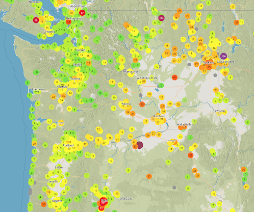
Let's start by looking at the air quality information from the PurpleAir network (below) this morning. Green is good air quality, yellow is declining, orange is of concern, and red/purple is unhealthy.
Mediocre air quality in the south Sound, but seriously degrading air quality around Spokane, northeast WA, and around Bend Oregon.
The origin of the smoke is clear: mainly smoke from burning wood for warmth. Parenthetically, a highly renewable energy source.
Traditionally, the main air quality problem in the Northwest has been from wood smoke, not summer wildfires. But woodsmoke has declined as an issue as more folks use natural gas fireplaces/heaters and air quality agencies (such as Puget Sound Clean Air Agency) promulgate and enforce burn bans during threatening situations. More extensive use of natural gas has helped clean our winter atmosphere. And increasing costs of oil and gas have also stimulated the use of wood.
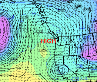
We are in a threatening situation now, as a strong inversion, with temperature increasing with height, has developed over our region. Inversions are very stable features that act as lids on the lower atmosphere.
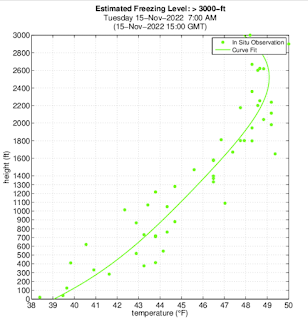
Above SeaTac Airport this morning at 7 AM, temperatures increased from 38-39F just above the surface (and even lower at the ground) to 49-50F around 2000 ft. A strong low-level inversion.


Comments
Post a Comment