Light Snow this Morning and the Warm Up Overnight. Plus, Strong Winds and Another Snow Threat....
As expected, some light snow came in this morning....a dusting for most and as much as .5-1 inches for favored locations (see below). The roads were warm enough and the air temperatures marginal enough that the snow rapidly melted on most roadway surfaces.
Ironically, the snow is associated with warming aloft.


The weather radar this morning around 11 AM showed very light precipitation over the region (blue colors), with heavier precipitation offshore).

This warm air aloft is leading a surface warm front, which will get to the coast around 6 PM, with a cold front a few hours behind.
So there will be a few light flakes in the air today, but nothing that will be substantial.
As precipitation increases on the coast later this afternoon, the higher intensity will drive down the snow level and produce some snow around the Olympics (see 3-h totals ending 4 PM below: rain is black and gray, snow in color). The Kitsap will be favored as southeasterly flow rises on the eastern slopes. Rain on the coast at that time.

And then a burst of wet snow from Lynnwood to Everett around 10 PM as the frontal moves through and warm air moves in (see below). It will all melt overnight. And it will seem warm when you wake up tomorrow.

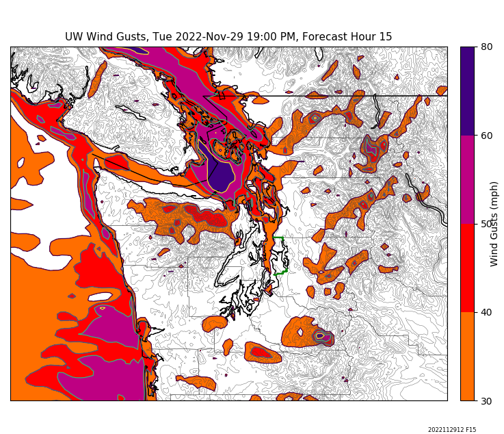
Then head to NW Washington this evening. The approaching front, interacting with the Olympic Mountains, will produce powerful southeasterly winds over Northwest Washington (see gust forecast for 7 PM tonight below).
If you take the Victoria Clipper tonight, bring your sickness bag...
Finally, I am watching the next interesting situation. By 10 PM Wednesday ANOTHER low-pressure center will move down the coast to NW Oregon, drawing in cool air over the region again (see below).

A little too far south to bring snow to Seattle and NW Washington, but Portland and SW Washington could get some white action. Will watch it....


Comments
Post a Comment