Lowland Snow is Coming on Tuesday to Washington State
Enough of the 1/2-inch snowfalls, more serious snow will hit the lowlands (and the rest of the state) on Tuesday.
Yesterday, some light snow showers reached the lowlands as cold air surged southward over the region.
Amounts ranged from nothing to about an inch at lower elevations, while more bountiful snow in the mountains brought a requirement for chains at Snoqualmie.

Light snow over Northeast Seattle.

Be careful driving: lots of slippery roads out there.
Today will be relatively benign and dry. But tomorrow is something else.
With cold air in place over the region, a Pacific weather system will approach. You can see the associated clouds on the latest infrared satellite image (see below).

This is not an ideal location of the low for lowland snow over Puget Sound--you want the low to take a more southward track and draw in cold air from the north as it approaches.

Less over SW Washington, where the temperatures are marginal but lots in the mountains (good skiing for the holiday period is guaranteed)
These kinds of marginal temperature situations are difficult and thus looking at many model solutions is useful. There is still (considerable) uncertainty regarding the exact location of the rain-snow line and precipitation distribution.
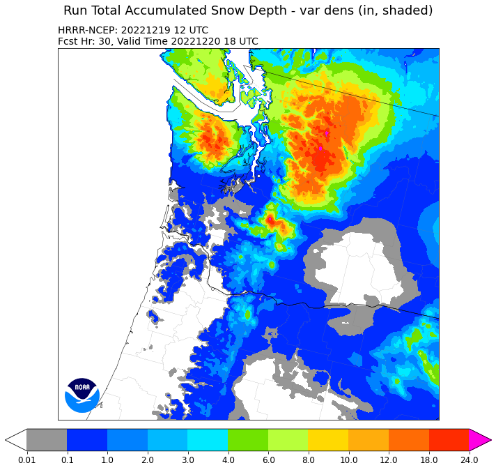
The UW model's snowfall total through Wednesday at 4 AM also has snow in NW Washington but also shows a rainshadow (snow shadow) north of Seattle, and more snow over the south Sound). But this is an older run than NWS HRRR forecast shown below.
.gif)
The European Center Model started more recently (10 PM Sunday), and also keeps most of the snow north of Seattle. And yes, large totals in the mountains.

All models bring fresh snow to the mountains of NE Washington.
Anyway, will keep an eye on the latest solutions, since this forecast is difficult with the southern edge of the snowfall area uncertain. It would be much easier to forecast snow in Nebraska, but more fun here!


Comments
Post a Comment