Snow Update Using the Most Powerful Tools Available
The most powerful technology for prediction is high-resolution ensembles of many forecasts.
The UW modeling effort has one of the most advanced and largest (most forecasts--about 25) around, far superior to the National Weather Service system. Such ensemble systems are very useful for presenting the uncertainty of the forecasts.
Let me show you what it is predicting for a few locations regarding snow. Cumulative snowfall is on the Y-axis and time is on the x-axis (in GMT/UTC, 18 is 10 AM, 06 is 10 PM PST). Snow depth will be less than snowfall.
Each line is a separate forecast and the black line is the average of them all (often a good forecast).
At Seattle-Tacoma Airport, there are around 3.5 inches of total snowfall, but the uncertainty is large, ranging from .5 inches to 8 inches. The uncertainty is closely coupled with the marginal temperatures for this event. The snow starts this evening.

At Bellingham, there is much more snow and more agreement among the predictions. Why more certainty? Because Bellingham is near the source of cold air (the Fraser River Valley) and sufficiently cold air is a near certainty.
.png)
.png)
.png)
.png)
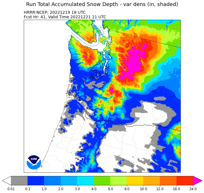
Another powerful tool is the frequently updates forecasts of the NOAA/NWS HRRR model. Its 10 AM run is consistent with the above, with lots of snow over NW Washington and in the mountains, with a substantial north-south gradient in snowfall over Puget Sound (less to the south)


Comments
Post a Comment