Sometimes in the weather business, everything happens in a short period.
This is such a period.
We will experience:
1. The coldest temperatures in several years on both sides of the Cascades
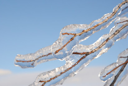
2. A freezing-rain storm particularly in the Gorge, the northern Willamette Valley, and south of downtown Seattle.
3. Powerful easterly winds reaching hurricane strength in the Columbia Gorge and the passes.
4. A rapid warm-up this weekend, with the return of typical rain and mild conditions.
Stage 1. Arctic Air
Eastern Washington is already very cold, with some temperatures getting below zero last night. Western Washington temps are well below normal.
To illustrate, here are the low temperatures this morning. In western Washington, primo cold air is pushing southwestward through the Fraser River Valley of NW Washington.
Tonight even colder air will move in, coupled with good radiational cooling to space because the clouds are thinning out aloft. Temperatures will drop as low as the teens away from the water in western Washington.
The forecast map (sea level pressure, temperatures shown by shading) for Thursday at 10 AM shows VERY cold air and high pressure over eastern Washington, and simply very cold air (blue) over the west. A HUGE pressure gradient (difference) separates them, with higher pressure to the east.
Stage 2: Strong Easterly Winds
This large pressure difference will drive powerful easterly (from the east) winds through the Cascade passes and particularly the Columbia River gorge. Winds from Cascade Locks to Troutdale in the Gorge could hit 60+ mph--and this will be cold Arctic air from eastern Washington.
Strong easterly winds will also descend the western slopes of the WA Cascades, with powerful gusts from North Bend to Enumclaw, with winds accelerating to the west down the Strait of Juan de Fuca. (see wind gust map at 10 AM Thursday). Greens and blues are the strongest winds.
Stage 3: Freezing Rain
We will have cold air in place. And then a Pacific frontal system with lots of moisture will approach late Thursday evening into Friday morning. A frontal system that will move in warmer air aloft.
Here is the precipitation forecast for 1 AM Friday morning--plenty of moisture.
Now, in the beginning, the precipitation will fall as snow throughout the region.
But that won't last as the front surges in warm air aloft from the south.
And this sets up a freezing rain situation. Let me explain using the figure below.
Initially, (right side of figure) the atmosphere is cold enough for snow through depth (virtually all precipitation in our region during the winter starts as snow aloft)
But as the front approaches, above-freezing air pushes in aloft and the snow starts to melt into water droplets.
Initially, the cold air is deep enough that the melted droplets refreeze into little ice spheres: this is sleet.
But eventually, as the warm air aloft deepens enough, the water droplets aloft do not have time to refreeze but cool down enough to become supercooled water...water that is liquid but still below freezing.
Then, when this supercooled water hits the cold surface (and it will be cold), it freezes on contact...producing freezing rain!
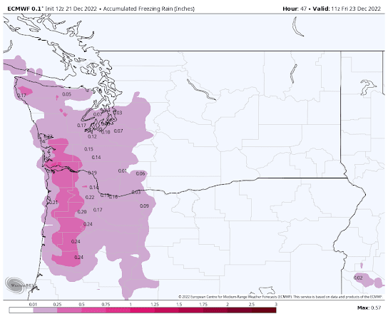
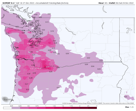
The latest European Center forecast for the accumulation of freezing rain is shown below.
Through 3 AM Friday, the freezing rain total is heavy in the coastal mountains and starts to spread inland.
Through 4 PM Friday, you can see substantial freezing rain totals over south Puget Sound, the Columbia Gorge, and northern Willamette Valley.
And through 4 AM Saturday, the ice piles up in the Columbia Gorge.
On Saturday, it all turns to rain.
Anyway, this looks like a major freezing rain event for the region. The airlines will have to be ready at SeaTac and particularly Portland, with Friday morning being particularly problematic.


Comments
Post a Comment