Cool air and snow showers on Friday for the western lowlands. More crazy stuff in California.
No, there won't be accumulating snow near sea level, but don't be surprised if you see a few flakes west of the Cascade crest on Friday,
The visible satellite image this morning (below) shows a strong spring-time front about to make landfall on the coast, with a swirl of clouds associated with a low-pressure area evident offshore. To the west, you can see the mottled, white and dark cloud areas associated with great instability, instability caused by cold air passing over warm water. That air is our future.


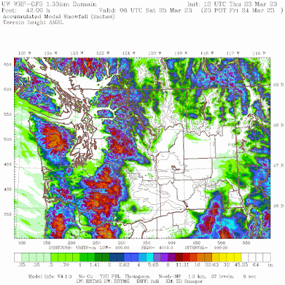
Below is the forecast SNOWFALL total through 11 PM Friday. Some very light snow south of Tacoma, with more over southwest Washington. Not only will the temperatures be marginal, but with the flow off the ocean being northwesterly, Puget Sound will be rain shadowed (or snow-shadowed) by the Olympics.
The Columbia Basin will also be rain shadowed, but the mountains will enjoy as much as a foot of new powder.
On Friday and Saturday, the lowlands will not get above the upper 40s, substantially cooler than normal.
California Madness
It is hard to believe, but ANOTHER powerful, record-breaking spring storm is being predicted for California. Below is the forecast sea level pressure and surface winds for 11 PM Monday, when a deep, intense low center will approach the coast north of San Francisco.

Will California get heavy precipitation from this system? Do kids like ice cream?
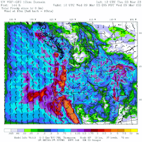
Take a look at the forecast precipitation totals through Wednesday morning. 3-7 inches more precipitation over the Sierra Nevada and northern CA. Perhaps the U.S. Drought Monitor will FINALLY drop severe drought over northern California. Just silly.


Comments
Post a Comment