A Three-Dimensional Heatwave
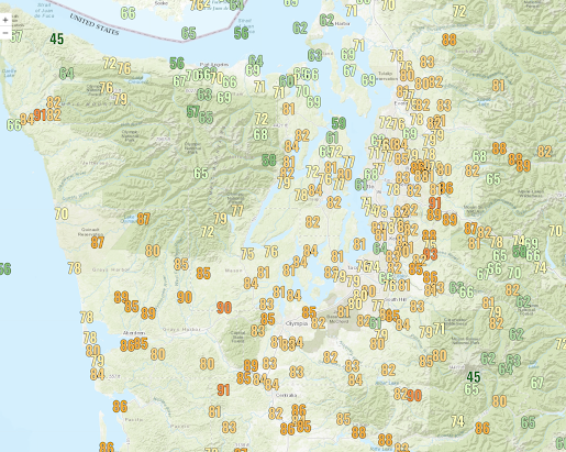
Yesterday (Friday, April 28) was the first moderately warm day of the Northwest "summer" season, with temperatures ranging from near 90F along the western slopes of the Cascades to around 70F near the water (see a map of high temps below)
It turns out that the Friday heat was very three-dimensional. Water provided some cooling, but the situation was much, much more complex than that.
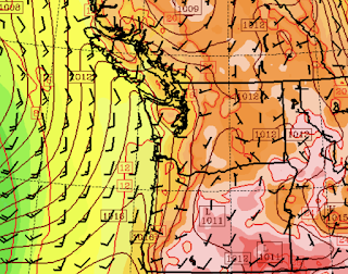
We need to start with the sea-level pressure pattern, with the one at 11 AM Friday shown below. High pressure over eastern Washington and low pressure over northwest Oregon and southwest Washington resulted in an easterly (from the east) wind moving over the Cascades. But at low levels around Puget Sound winds were from the north, since pressures were higher over northwest WA and lower over western Oregon. Near mountains, winds like to go from high to low pressure.
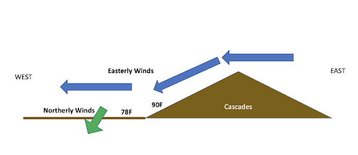
A schematic of the situation around Puget Sound is shown below (sorry, I am not much of an artist). The easterly winds sinking on the Cascades warmed by compression, and thus very warm air was found over the lower western slopes of the barrier.
But the descending air could not reach the western lowlands because of the cool, northerly flow near the surface there. Cold air is denser than warm air and wins the battle to stay near the surface.
Very three-dimensional!
Now the temperatures today (Saturday) are again going to be a complex story...but a very different story.
The pressure pattern has changed greatly. The low-pressure west of the Cascades has now shifted into eastern Washington. Thus, the easterlies over the Cascades are history. And with higher pressure offshore, cool marine air has started to move in.
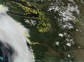
One sign of this onshore intrusion of marine air is the eastern movement of marine low clouds this morning (see below).
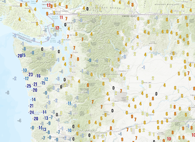
Now let me show you a fascinating figure: the 24 h change in temperature ending 11 AM Saturday.
Mama Mia! Hugely colder today along the coast where marine air is surging in. Yesterday, the easterly, offshore-directed flow made the coast quite warm
Notice how it is warmer today from Seattle northward, where the cool northerly flow has weakened since the north-south pressure difference is less since the low pressure has moved inland.
East of the Cascades today is a bit warmer in general.
Tomorrow, the temperatures will crash in the west as a potent low-pressure system approaches the coast and an associated front makes landfall (see pressure and temperature forecast for mid-day Sunday below).



Comments
Post a Comment