A short Northwest heatwave is ahead and it will come on with a vengeance on Friday.
So get those tee shirts, shorts, sunglasses, and a cool drink ready. It will be all the more jarring after an unusually cold spring.
Many of you will experience temperatures in the 80s....
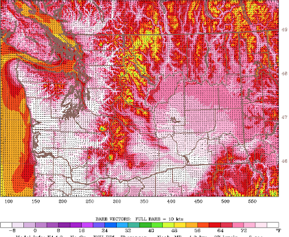
Let me start with temperatures predicted on Friday around 5 PM on Friday by the UW WRF model. The white areas are places where temperatures are predicted to rise to 80F or more. White hot.
Temperatures will be cooler near Puget Sound and over Northwest Washington. So if you like heat, move inland and south. And cancel the trip to southern California--it will be warmer here!
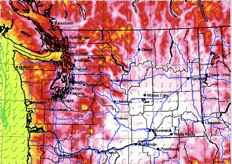
Saturday will be a transitional day, with cooler air starting to move inland on the coast. But still getting to the mid-70s in the western Washington and Oregon interior. Expect further warming over the Columbia Basin, where mid-80s will be commonplace (see the forecast for 5 PM Saturday below).
A state-of-the-science approach to forecast uses high-resolution ensembles of many forecast runs, each a little different. Below are the temperatures predicted for SeaTac from the UW high-resolution ensemble system. Most model simulations are going 80-85F on Friday, which would be a record for that date. About the same in the Tri-Cities. Add 3-5 degrees for Portland.
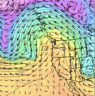
The origin of this warmth is an impressive upper-level ridge that will develop along the West Coast on Friday (see below). Such ridges are associated with warm air aloft that gets even warmer as it rapidly sinks into the lower atmosphere (and thus warms by compression).
This high pressure aloft will cause the development of high pressure to our east that will result in easterly (from the east) flow over the region (see sea level pressure map, with low-level temperatures and wind). Easterly flow will produce intense sinking on the western side of the Cascades and the Olympics that will result in substantial compressional warming.
The temperatures should be warmest just west of the western slopes of the Cascades.
The warm air results in lowered atmospheric pressure, called the thermal trough (apparent in the above surface map). And easterly flow keeps the cool marine air away.
A classic pattern during our local heatwaves.
Enjoy.
___________________
The Northwest Weather Workshop agenda and information are online. This meeting, which will take place on May 12-13th in Seattle, is the major weather meeting of the year in the Northwest. We have a varied and interesting agenda. The meeting is open to everyone and if you want to attend you must register (on the website).
We will also have a banquet/talk at Ivar's Salmon House on Friday May, 12. This is a fun meeting and will be hybrid (in person and on zoom).


.png)


.png)


Comments
Post a Comment