Virtually every week someone asks me about a strange-looking weather radar feature that is often along the Washington coast.
UFOs? Chinese balloons? A stationary flock of birds? Or could it be the ocean? The answer is revealed below.
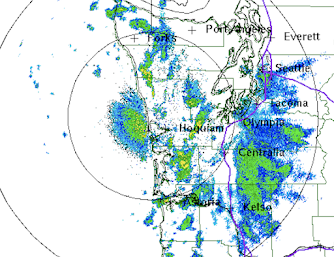
Below is an example on April 11th around 7 AM from the National Weather Service Langley Hill radar near Hoquiam Washington (the radar is shown above). You see the bluish area west of Hoquiam, just offshore on the central Washington coast? That is the feature.
The other features are areas of precipitation.
They move. The area off of Hoquim stays put.
The image above is for the lowest scanning angle that is typically used in U.S. weather radars, a half-degree (0.5 degree) above the horizontal. However, the Langley Hill radar was giving permission to have a lower scan angle (roughly 0.2 degrees) due to the intercession of Senator Maria Cantwell.
The image from that angle at the same time is shown below.
The feature has gotten stronger and larger! A big hint.
Reflecting Off the Ocean
The Langley Hill radar is close enough to the coast that the radar beam at lower scan angles actually hit the ocean surface and reflects back to the radar receiver. That produces the false echos. If you climb up the tower (which I did during the dedication), one can actually see the Pacific (see the image below taken about 2/3rds up the tower).
One way to confirm the radar beam is looking at the ocean is to view the Doppler velocity field from the radar, which provides the speed of the target towards or away from the radar (see below).
The velocity of the "target" is essentially zero...so the object is stationary (which is generally not true for precipitation, which is blown around by the wind).
The intensity of the return off the ocean is influenced by the lower atmospheric temperature structure. When there is a strong low-level inversion (temperature increasing with height), the radar beam tends to be bent towards the surface, leading to a strong signal. This is what is known as a stable situation.
When temperatures decline rapidly with height, the beam is higher and there is less ocean return (less stable situation).
One thing you can be sure of: that strange feature along the coast does not indicate coastal rain. Or UFOs.


.gif)


Comments
Post a Comment