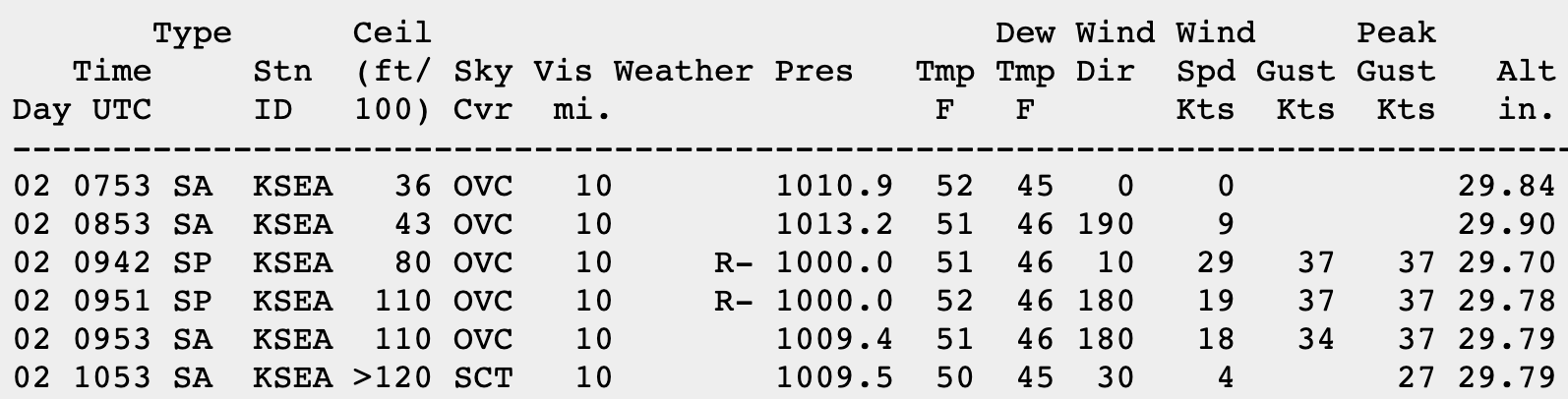
You would not have wanted to land at Seattle-Tacoma Airport between 2 and 4 AM on Tuesday morning. (observations shown below)
At 1:53 AM, the winds were from the south at 9 knots (10 mph).
At 2:42 AM the winds switched to north-northeast with gusts to 37 knots
9 minutes late (2: 51 AM) the winds turned back to the south, with gusts to 37 knots.
At 3:43 AM the winds switched to the northeast at 27 knots
At a station near the airport, winds gusted to 63 mph.
An aircraft either landing or taking off could have had a dangerous wind reversal and loss of lift. Fortunately, this is the quietest portion of the day at the airport.
The strong winds did result in hundreds of power customers losing power and a number of trees downed.
A street scene on Tuesday morning near SeaTac, courtesy of Michael Snyder
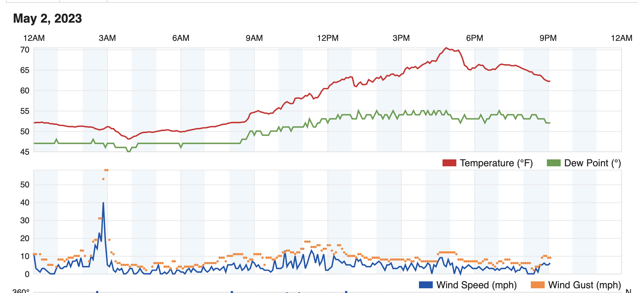
These strong winds were highly localized near SeaTac (see maximum gusts on Tuesday morning below)
The winds were not only localized in space but were short-lived in time, as shown by a plot of winds near SeaTac below (second panel). A sudden jump in the sustained winds (blue line) to around 40 mph and the gusts (orange) to around 60 mph. The strong winds occurred only for roughly 15 minutes.
But that is not the end of the weather weirdness. Look at the pressures! A sudden jump up and then a jump down! (see below)
Local weather enthusiast Michael Snyder lives near the airport and his barometer showed the same high amplitude (about 3 hPa up and down) oscillation (see below)
One final observation. Local weather radar indicated a weak, dying line of showers going through during this period (the radar image at 2:09 AM is displayed below). Not impressive but showing that a line of upward motion was occurring.
The Origin of this Mysterious Feature
This events was a good example of a high-amplitude atmospheric gravity wave.
A wave that forms on an interface between air of two different densities.
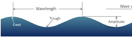
You are all experts on gravity waves.... just look at the waves on the ocean surface (see below)
Ocean gravity waves form at the interface of a dense fluid (water) and a less dense fluid (air). When some water is displaced upward, gravity pulls it down, with the result being a wave-like motion.
On the morning of Tuesday, May 2nd, the atmosphere over Puget Sound developed a "two-fluid" structure. With cool dense air below and warmer, less dense air above.
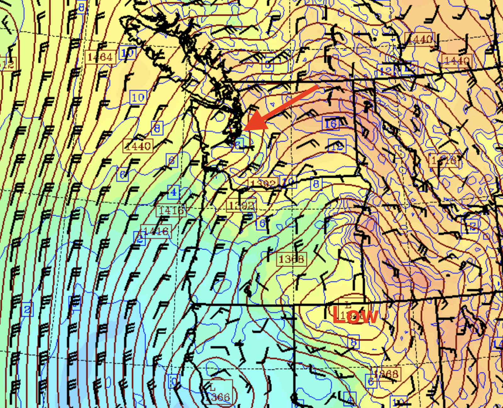
How did this happen? A low center moved westward to our south, resulting in easterly (from the east) flow aloft that brought in a slug of warm air over Puget Sound (see map below). At the same time, colder, denser air was in place at low levels.
Between the two there was an inversion....a stable layer in which temperature warmed with height. A situation, not unlike the interface between water and air above.
850 hPa heights (roughly 5000 ft), winds, and temperatures
(shading, reddish colors are warmer) at 2 AM PDT Tuesday morning
The westward-moving low provided the impulse to produce a wave on the interface between the cold low-level air and the warmer air above. It may have done this by producing some stronger thunderstorms east of the Cascade crest that interacted with the inversion to produce the strong wave. In fact, there was lightning and relatively high tops associated with thunderstorms approaching the Cascades around 1 AM (see lightning strokes below from 12:30-1 AM)The wave was not large in scale (about 100 miles) and was moving to the northwest. The large pressure differences with the wave resulted in the narrow zones of strong winds (winds are produced by differences in pressure).
To illustrate, here is a map of the observed pressures and winds around 3 AM (most of the observations in this map were taken around 2:50 AM). You can see the trough (or low-pressure portion) of the wave (pressures around 1007 hPa), which I have indicated by a dashed red line.
Northerly winds to the north of the low pressure, southerly winds to the north.
The most amazing thing about this whole event was the ability of UW high-resolution model to PREDICT it. I still can't believe it.
The predicted pressure pattern for 3 AM clearly shows the wave
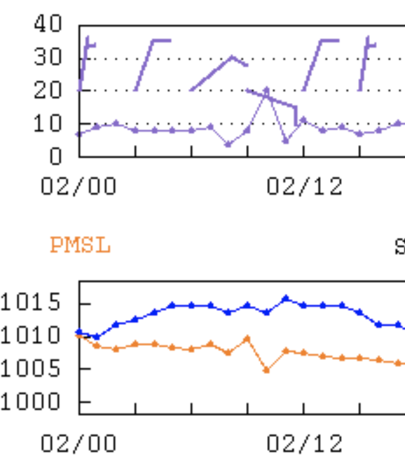
And the forecast wind (top panel below) and pressure (bottom panel, orange line) at Seattle-Tacoma Airport clearly predicts the event. We have come a very, very long way in high-resolution prediction.
Finally, let me note that this event, although rare, is not unique. For example, a similar event occurred in September 1990 and was written up in an article by a National Weather Service forecaster (Bruce Bauck). The event this week was one of the strongest such waves in spring.
__________________
The Northwest Weather Workshop agenda and information are online. This meeting, which will take place on May 12-13th in Seattle, is the major weather meeting of the year in the Northwest. We have a varied and interesting agenda. The meeting is open to everyone and if you want to attend you must register (on the website).
We will also have a banquet/talk at Ivar's Salmon House on Friday May, 12. This is a fun meeting and will be hybrid (in person and on zoom).


.png)


Comments
Post a Comment