NOTE: Last Day to Register for the NW Weather Workshop (see bottom of blog for information.
______________________________
I have gotten a number of emails wondering about the impacts of the developing El Nino on our summer weather.
And several media outlets have already suggested that El Nino will cause enhanced heatwaves around the world...so folks are a bit worried (some samples below)
The Bottom Line: The correlation of El Nino (warmer than normal water in the central and eastern tropical Pacific) on Northwest summers is quite weak. The El Nino signal tends to increase after January 1.
NOAA provides a number of graphics and studies that have taken on this question.
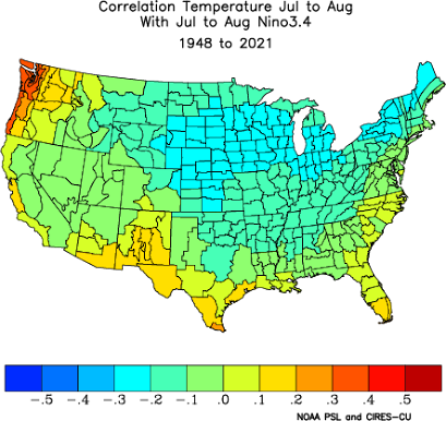
For example, below is the correlation between summer (July-August temperatures) and the temperature in the central/eastern tropical Pacific (the Nino3.4 area). A positive value would be consistent with El Nino causing the summer temperatures to warm.
Interestingly enough, El Nino results in COOLING over most of the U.S.. But western Washington and Oregon are the stand-outs, with a modest positive correlation of about 0.4. This means about 16% of the variability of summer temperature in our area might be explained by warmer tropical sea surface temperatures.
And western Washington and Oregon tend to be a bit warmer during El Nino summers.
But you probably don't want to know about correlations, but how much warmer it might be.
Below is the answer for the area around western Washington for June-July-August. It suggests that the median temperature (the red lines) is about 0.5 degrees F warmer during El Nino summers than neutral (normal) summers. Not much.
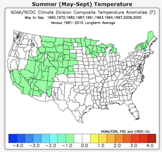
Perhaps a better map shows the summer (May through September) temperature anomaly from normal for El Nino years (below). Near normal (within .5 degrees of typical) over the Northwest and cooler than normal over the Southwest, and the high plains.
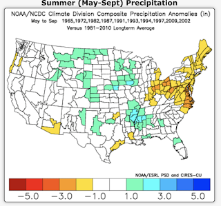
What about summer precipitation during El Nino years? As shown below, near normal precipitation over the western U.S., slightly wetter than normal in the central U.S., but a bit drier than normal over the Northeast.
I would show you more graphics, but the answers are consistent. The El Nino influence on weather is very weak or non-existent over the Pacific Northwest over summer and thus provides meteorologists no useful prediction signal during our warm season.
Sorry....wish I could say more!
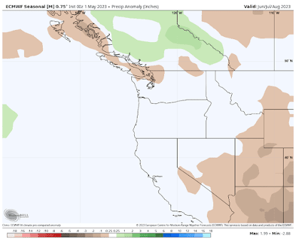
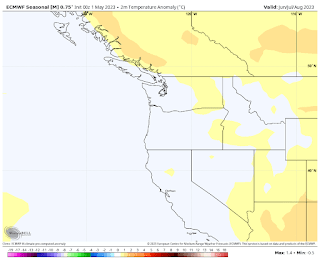
Consistent with the above, the latest European Center model seasonal forecast predicts near-normal precipitation over the Northwest during June/July/August.
For temperature, conditions are predicted to be near normal over Washington, Oregon, and California but warmer than normal over southwest Canada.
A prediction of near-normal conditions will probably not secure much attention from the media. Can you imagine this?
__________________
The Northwest Weather Workshop agenda and information are online. This meeting, which will take place on May 12-13th in Seattle, is the major weather meeting of the year in the Northwest. We have a varied and interesting agenda. The meeting is open to everyone and if you want to attend you must register (on the website).
We will also have a banquet/talk at Ivar's Salmon House on Friday May, 12. This is a fun meeting and will be hybrid (in person and on zoom).



.png)


Comments
Post a Comment