The media has been going big on potential disasters in California.
Drought warmings earlier this winter have been replaced by scary warming of major flooding as an incipient "Big Melt" rapidly melts the record-breaking snowpack over the Golden State.
Desperately, California reservoir managers have been dumping water in a race to prevent reservoirs from being overtopped and potentially damaged as temperatures warm.
But it now appears that the weather gods have decided to be kind, and meteorological salvation is now in California's future.
An incipient Big Chill is about to reduce the Big Melt to tolerable levels.
Using the European Center ensemble prediction system, the best in the world, here are the predicted differences from normal of surface air temperatures around California for the next week. This is also called the anomaly from climatology.
Blue indicates colder than normal; green is much colder than normal (by 8°F or more).
Wow. Lots of green over the entire state. The mountains above LA will be frigid.
Consider Truckee Airport at 5600 ft in the Sierra Nevada range (see below). No heatwave there, with temperatures most nights dropping into the 20s and many days only getting into the lower 40s.
The National Weather Service's extended temperature forecast for the entire month of May from their GFS model is for substantially cooler than normal over California.
And did I mention that Pacific Ocean sea surface temperatures along the West Coast are MUCH colder than normal? See below. Blue colors indicate below-normal ocean temps.
In short, such suppressed temperatures will be California's near-term future and will greatly decrease snowmelt.
This is going to be one of the coolest Mays in California history if the models are correct.
So let's give this a name: The California Big Chill.
I know your next question. Why is California going to be SO COLD during the next week or so?
The reason: a deep trough, low-pressure area, not unlike some of the features seen for much of the late winter.
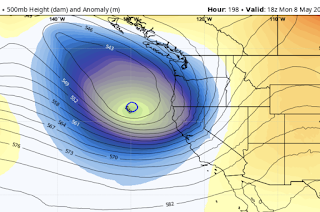
Below is the upper-level map for 2 PM Wednesday. The solid lines show the heights of 500 hPa pressure (you can think of this as the pressure around 18,000 ft) and the shading is the difference from normal of these heights/pressures.
An unbelievably strong low off California. Very unusual for this time of the year.
This low sticks around for a few days and then ANOTHER strong low begins to move in from the Northwest on Monday (see below).
A cool May will allow the Sierra Nevada snowpack to slowly melt. Reservoirs will fill but not overtop. Flooding will be lessened.
Bottom line: it appears that California will get through this unusually wet/snowy period without serious flooding.
But one thing is clear: the political "leadership" in California has been deeply irresponsible during the past decades by not adding more reservoir capacity. No new reservoirs have come online in the Golden State during the past 40 years, as the population has doubled.
More reservoirs would not only have promoted safety by holding all the wet bounty for slow release, but would make huge water resources available for the growing population and agriculture in the State.
There is too much talk about global warming and not enough rational planning and action to deal with the known environmental challenges of the state.
___________________
The Northwest Weather Workshop agenda and information are online. This meeting, which will take place on May 12-13th in Seattle, is the major weather meeting of the year in the Northwest. We have a varied and interesting agenda. The meeting is open to everyone and if you want to attend you must register (on the website).
We will also have a banquet/talk at Ivar's Salmon House on Friday May, 12. This is a fun meeting and will be hybrid (in person and on zoom).


.png)


Comments
Post a Comment