The Upcoming Spring Heatwave
During most Mays in the Northwest, there is a several-day period of warm weather, driven by the strengthening sun and a favorable atmospheric circulation (high pressure and offshore-directed winds).
During such periods, the western lowlands can surge well into the 80s, while the Columbia Basin warms well into the 90s.
Such a period is ahead starting this weekend.
Just to give you some perspective, below is a plot of the warmest temperature each year in Seattle for the period 5-25 May. Most but not all years have a least one May day above 80F, with a number of years seeing temperatures surge about 85F. Interestingly, there is no upward trend in warm days over the period of record.
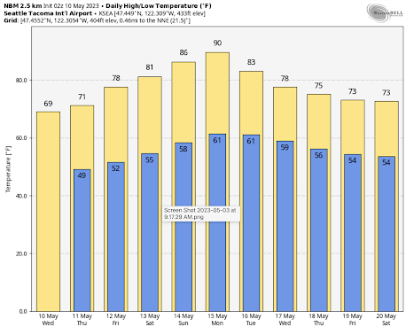
The latest forecast from the NOAA/NWS National Blend of Models, which combines the forecasts of many modeling systems statistically, predicts the mid-80s over the weekend in Seattle, surging to 90F on Monday.
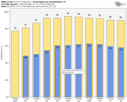
The Tri-Cities will be firmly in the 90s starting on Friday and will stay there for days (see the prediction for Pasco below).
The origin of this warm bounty will be the development of a ridge of high pressure along the West Coast, replacing the low-pressure trough that has hung around FOREVER.
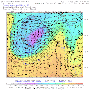
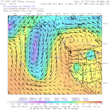
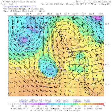
Let me illustrate the changes by showing you a series of upper-level maps (500 hPa pressure, about 18,000 ft).
By Friday at 5 PM, an upper-level ridge, accompanied by warm (yellow) temperatures has built northward from California into southern BC.
The pattern gets complex by Sunday at 5 PM, with high pressure/heights over British Columbia and eastern (from the east) flow over the Northwest
This pattern is in no hurry to move out, with the British Columbia high-pressure ridge still in place 24 hr later.
.png)


Comments
Post a Comment